NAVIGATION
ref. # 011 navigation -Astrolabe
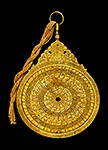 "The astrolabe is a very ancient astronomical computer for solving problems relating to time and the position of the Sun and stars in the sky. Several types of astrolabes have been made. By far the most popular type is the planispheric astrolabe, on which the celestial sphere is projected onto the plane of the equator. A typical old astrolabe was made of brass and was about 6 inches (15 cm) in diameter, although much larger and smaller ones were made.
Astrolabes are used to show how the sky looks at a specific place at a given time. This is done by drawing the sky on the face of the astrolabe and marking it so positions in the sky are easy to find. To use an astrolabe, you adjust the moveable components to a specific date and time. Once set, much of the sky, both visible and invisible, is represented on the face of the instrument. This allows a great many astronomical problems to be solved in a very visual way. Typical uses of the astrolabe include finding the time during the day or night, finding the time of a celestial event such as sunrise or sunset and as a handy reference of celestial positions. Astrolabes were also one of the basic astronomy education tools in the late Middle Ages. Old instruments were also used for astrological purposes. The typical astrolabe was not a navigational instrument although an instrument called the mariner's astrolabe was widely used in the Renaissance. The mariner's astrolabe is simply a ring marked in degrees for measuring celestial altitudes."
picture: Astrolabe, by Muhammad Mahdi al-Yazdi, Persian, c. 1660.
©: www.astrolabes.org
more on: www.hps.cam.ac.uk
tags: #navigation #astrolabe
011a navigation -Lunar distance (navigation)
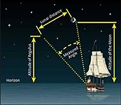 In celestial navigation, lunar distance is the angle between the Moon and another celestial body. The lunar distances method uses this angle, also called a lunar, and a nautical almanac to calculate Greenwich time. By comparing that calculated time to the measured local time, the navigator can determine longitude. The method was used for some time during the 17th century, before the introduction of the marine chronometer. A similar method uses the positions of the Galilean moons of Jupiter.
©: Wikipedia
tags: #Lunar distance
ref. # 011b navigation -Cadran solaire multiple en diptyque (Compass)
 MILLER Leonhart (actif de 1602 à 1651), ou MULLER
Cote cliché :09-583110 No D'INVENTAIRE: OA10738
Note de l'image: Face extérieure a : rose des vents à seize directions
Période: 17e siècle Europe (période) - période moderne
Site de production: Nuremberg (origine)
Technique / matière: acier, alliage cuivreux, ivoire, verre (matière)
Dimensions: Hauteur : 0.092 m Largeur : 0.056 m Profondeur : 0.018 m
Mode d;entrée: Don Mme Nicolas Landau, 1979
Localisation: Paris, Musée du Louvre
Crédit Photo: (C) RMN-Grand Palais (Musée du Louvre) / Jean-Gilles Berizzi
©: www.photo.rmn.fr
Pin, rest
tags: #compass #boussole, #rose de vents, #cadran solaire
ref. # 011c navigation -variations of the Compass
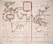 A new and correct sea chart of the whole world showing the variations of the compass as they were found in the year 1700.
taken from a very readable website amongst other things on the famous timekeeper of John Harrison, called: 'random acts of cartography'
©: National Maritime Museum, Greenwich, London>
tags: #National Maritime Mueum London #compass
ref. # 011d navigation -Magnetic Compass, China 11th century
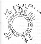 Magnetic Compass (c. 11th century) Country: China Inventor: Unknown
The magnetic compass was first used and invented in ancient China´s Han Dynasty around the 2nd century B.C. It was originally used for divination and was not used for navigation until around the Song Dynasty in the 11th century A.D.
©: totallyhistory.com
First recorded use of a compass at sea:
- "The Customs of Cambodia" by Yuan dynasty diplomat Zhou Daguan, he described his 1296 voyage from Wenzhou to Angkor Thom.
- 48 point compass www.geog.ucsb.edu/~kclarke/Geography126/Lecture01.pdf
tags: #China compass
ref. # 011e navigation -Compass
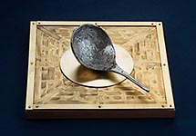 By the time of the T'ang dynasty (7-8th century CE) , Chinese scholars had devised a way to magnetize iron needles, by rubbing them with magnetite, and then suspending them in water (early 11th century). They also had observed that needles cooled from red heat and held in the north-south orientation (the earth's axis) would become magnetic(Smith.Inst.)
During the Song Dynasty (960-1279) many trading ships were then able to sail as far as Saudi Arabia without getting lost. The compass was introduced to the Arab world and Europe during the Northern Song Dynasty. The spread of the compass to Europe opened the oceans of the world to travel and led to the discovery of the New World.(www.chinaculture.org)
"The magnetic compass is an invention whose origin is uncertain, but which seems to have moved from China along the land and sea routes toward the west. It was originally a lodestone or magnetized metal floating in a bowl of liquid used to show direction. The Chinese oriented it toward the south, and Indian Ocean accounts describe a magnetized iron fish floated in a bowl, whose head would point south to show direction at sea. Dry-mounted compasses in which the needle rotates on a pin over a paper or inscribed compass rose to show direction may have originated in Europe, in Spain, Italy, or elsewhere. Historians today must base their ideas on written descriptions, which leave many gaps."
www.islamicspain.tv
©: www.smith.edu
Also: See for more on maritime China #037 and next
larger image
tags: #china #magnetic compass
011f navigation -Portuguese Compass
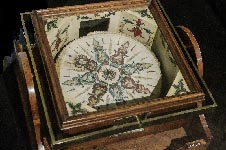 Portuguese sea compass 1744,
Inscription: Manoel Ferreira Portugal, made in Lisbon in 1744.
wood, metal, iron and paper ©: Robert Schilder 2015, photographed, n Musée de la Marine, Paris
tags: #portugal #magnetic compass
011g navigation -Cercle de Mendoza
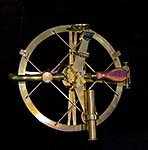 "Reflecting instruments are those that use mirrors to enhance their ability to make measurements. In particular, the use of mirrors permits one to observe two objects simultaneously while measuring the angular distance between the objects. While they are used in many professions, they are primarily associated with celestial navigation, as the need to solve navigation problems, in particular the problem of the longitude, was the primary motivation in their development"
Joost van Breen's reflecting cross-staff
Invented in 1660 by the Dutch Joost van Breen, the spiegelboog (mirror-bow) was a reflecting cross staff (#150c). This instrument appears to have been used for approximately 100 years, mainly in the Zeeland Chamber of the VOC (The Dutch East India Company)."
The reflecting circle is a complete circular instrument graduated to 720° (To measure distances between heavenly bodies, there is no need to read an angle greater than 180°:, since the minimum distance will always be less than 180°)."
"Joef de Mendoza y Ríos redesigned Borda's reflecting circle (London, 1801). The goal was to use it together with his Lunar Tables published by the Royal Society (London, 1805). He made a design with two concentric circles and a vernier scale and recommended averaging three sequential readings to reduce the error. Borda's system was not based on a circle of 360°: but 400 grads (Borda spent years calculating his tables with a circle divided in 400°:). Mendoza's lunar tables have been used through almost the entire nineteenth century (see Lunar distance (navigation)."
©: Wikipedia
tags: #Cercle de Mendoza #reflecting circle
011h navigation -Pillar Sundial
 Solar clock with a cylinder targeted for the latitude of venice; 17th century.
paper and wood, H 9,7 cm. diam. 1,9 cm. Correr Museum, venice. inv. CLXXIX n.38
©: photo Claudio Francini (from the book
tags: #pillar sundial #Solar clock #venice
011j navigation -Gnomon
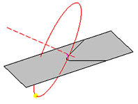 A gnomon, consisting of a vertical stick with a small sphere at the top. If we mark the center of the elliptical shadow of the sphere, we can get an accurate shadow length that corresponds to the elevation angle of the center of the Sun above the horizon. Determining Latitude with a Gnomon.
Apparently, this instrument was already used by Pytheas (325BC) #022
©: people.physics.tamu.edu, picture: Wikimedia CC animated .gif by Cmapm
tags: #sundial #Gnomon #pytheas
012 navigation -John Harrison H-1
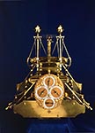 "The measurement of longitude is important to both cartography and navigation. Historically, the most important practical application of these was to provide safe ocean navigation. Knowledge of both latitude and longitude was required. Finding a method of determining longitude took centuries and involved some of the greatest scientific minds."
Marine timekeeper, H1.
"This is the first experimental marine timekeeper made by John Harrison in Barrow-on-Humber between 1730 and 1735 as a first step towards solving the longitude problem and winning the great £ 20,000 prize offered by the British Government. Now known as 'H1', the timekeeper is unaffected by the motion of a ship owing to its two interconnected swinging balances. It compensates for changes in temperature and thanks to extensive anti-friction devices, runs without any lubrication."
more: en.wikipedia.org/wiki/History_of_longitude
©: National Maritime Museum, Greenwich, London collections.rmg.co.uk
There's a (New York Times bestseller) book about John Harrison and his famous clock: Pinterest
tags: John Harrison #Timekeeper #H1 #longitude
012a 'navigation' -John Harrison's H1 marine chronometer
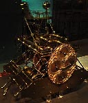 It took Harrison about five years to develop this chronometer. Its sea trial was in 1735 on HMS Centurion to Lisbon and HMS Orford returning to England. It weighs 34 kilograms (75 lb) and was originally housed in a glazed wooden case about 120 centimetres (3.9 ft) in each dimension.
Instead of a pendulum, it employs a pair of rocking bars with balls on the end and constrained with helical springs. The equal and opposite movement of these bars was less susceptible to being affected by a ships movement than a pendulum would be. Harrison's grasshopper escapement connects the bars with the rest of the mechanism. Some of the cog wheels are of wood which has self-lubricating properties. Gridirons provide temperature compensation by modifying the effective length of the helical springs.
It took Harrison about five years to develop this chronometer. Its sea trial was in 1735 on HMS Centurion to Lisbon and HMS Orford returning to England. It weighs 34 kilograms (75 lb) and was originally housed in a glazed wooden case about 120 centimetres (3.9 ft) in each dimension.
Instead of a pendulum, it employs a pair of rocking bars with balls on the end and constrained with helical springs. The equal and opposite movement of these bars was less susceptible to being affected by a ships movement than a pendulum would be. Harrison's grasshopper escapement connects the bars with the rest of the mechanism. Some of the cog wheels are of wood which has self-lubricating properties. Gridirons provide temperature compensation by modifying the effective length of the helical springs.The bar-balances like elongated dumbells do not run in conventional bearings. Instead they roll on pairs of plates set at 45° to the vertical and at 90° to each other. These plates, which only move through very short distances are on the ends of long arms pivoted near the bottom of the instrument. The counterweights to these arms are the brass knobs looking like control knobs at the very bottom. This and other devices mean that the clock requires no lubrication. Harrison Jonathan Betts National Maritime Museum, Greenwich, 2007 Ref: The Illustrated Longitude, Dava Sobel and William J. H. Andrews, Fourth Estate, London, 1998. (rectifications?)
Read this article in the Guardian
©: Wikipedia Commons
tags: #John Harrison #marine #chronometer #H1 #National Maritime Museum

