PORTUGAL

131 -'King Manuel's dream of the rivers Ganges and Indus'
"... CAMÕES has the Indus and the Ganges appear to the Portuguese king Manuel in a dream, in the guise of wise old men who urge him to subjugate the people of India - whereupon the epic's king decides to prepare a fleet for the Indian voyage under the command of Vasco da Gama..."google books; 'In the World Interior of Capital' by Peter Sloterdijk
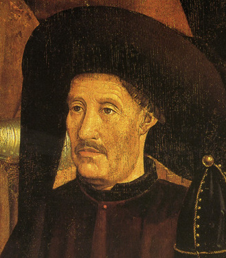
Sonho profético de D. Manuel com os rios Ganges e Indo. Numa edição de Os Lusíadas.
Date: 1880
Source: Biblioteca Nacional de Portugal
©: Wikipedia
, tags: #King Manuel #Portugal #Os Luciadas
015 Portugal -Hendrik the Navigator
 "Prince Henry (Henrique) the Navigator (1394-1460) was a Portuguese royal prince, soldier, and patron of explorers. Henry sent many sailing expeditions down Africa's west coast, but did not go on them himself. Thanks to Prince Henry's patronage, Portuguese ships sailed to the Madeira Islands (Joao Goncalves Zarco, 1420), rounded Cape Bojador (Eannes, 1434), sailed to Cape Blanc (Nuno Tristao, 1441), sailed around Cap Vert (1455), and went as far as the Gambia River (Cadamosto, 1456) and Cape Palmas (Gomes, 1459-1460).
School of Navigation: About 1418, Prince Henry started the first school for oceanic navigation along with an astronomical observatory at Sagres, Portugal. In this school, people were trained in nagivation, map-making, and science, in order to sail down the west of Africa."
©: text: www.enchantedlearning.com
tags: #Hendrik the Navigator #Henry the Navigator
See also ref. #196
015a Portugal -Volta do Mar
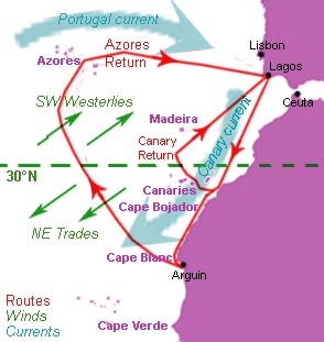 "'Volta do mar', 'volta do mar largo' or 'volta do largo', (the phrase in Portuguese means literally turn of the sea but also return from the sea) is a navigational technique perfected by Portuguese navigators during the Age of Discovery in the late fifteenth century, using the dependable phenomenon of the great permanent wind wheel, the North Atlantic Gyre. This was a major step in the history of navigation, when an understanding of winds in the age of sail was crucial to success: the European sea empires would never have been established had the Europeans not figured out how the trade winds worked"
General depiction of the winds (green) and currents (blue) and the approximate sailing routes (red) of Portuguese navigators during the era of Henry the Navigator (c.1430-1460). The further south the ships go, the wider the return, and the more open sea sailing required. Based on the description in Gago Coutinho, 1951, A Náutica dos Descobrimentos"
©: CC wikipedia published by Walrasiad
tags: #Volta do Mar
015b Portugal -Cantino Planisphere
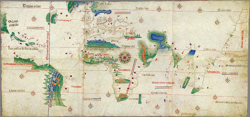 The Cantino planisphere of 1502 shows the line of the Treaty of Tordesillas. anonymous Portuguese (1502) - Biblioteca Estense Universitaria, Modena, Italy
"The Cantino planisphere, completed by an unknown Portuguese cartographer in 1502, is one of the most precious cartographic documents of all times. It depicts the world, as it became known to the Europeans after the great exploration voyages at the end of the fifteenth and beginning of the sixteenth century to the Americas, Africa and India. It is now kept in the Biblioteca Universitaria Estense, Modena, Italy"
See also ref. #148 (Diogo Ribeiro map)
©: PD wikipedia
tags: #Cantino Planisphere #Treaty of Tordesillas
015c Portugal -Pradão de Santa Maria
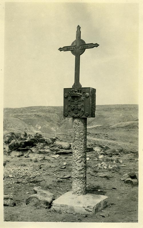 Padrão de Santa Maria, de Diogo Cão, clichè de um sargento canhoneiro Cuanza, fotos para a exposição colonial portuguesa (1934)
1482, the Portuguese navigator Diogo Cão reached the Cape of Santa Maria when looking for the southernmost point of the African continent. The expedition's goal was to look for a passage that would allow circumnavigate Africa. To claim the Portuguese sovereignty, Diogo Cao erected on top of the out a standard, which remained in that position until his transfer to Lisbon in 1892. On his first trip Diogo Cão did not reach your goal, and returned to Portugal with slaves."
©: PD Wikipedia (by Victorcouto "Cette , oto faisait, artie d'un ensemble déstiné a l'Exposição Colonial Portuguesa" de 1934
tags: #pradao #santa maria #diogo cao
016 Portugal -Vasco da Gama
 Alfredo Roque GAMEIRO (1864-1935) 'A partida de Vasco da Gama a Ìndia in 1497' (1900) Dimensions fol.: 42 x 57 cm. Current location: National Library of Portugal Cota local: E. 294 A.
©: Biblioteca Nacional de Portugal
tags: #vasco da gama
TIMELINE
ref. # 016a Portugal -Vasco da Gama
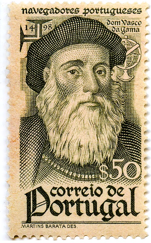 Stamp with portuguese explorer, discoverer Vasco da Gama
©:
tags: #vasco da gama
TIMELINE
147 -Vasco-da-Gama
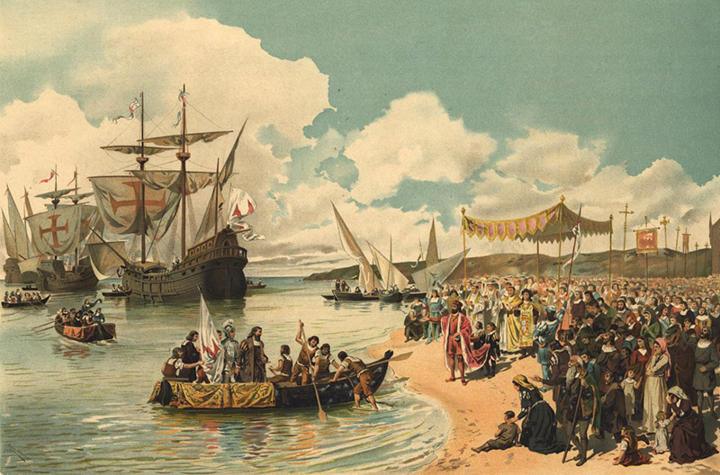 Alfredo Roque GAMEIRO (1864-1935) 'A partida de Vasco da Gama a Índia em 1497'. (circa 1900)
Dimensions: fol.: 42 x 57 cm Current location: National Library of Portugal
Alfredo Roque GAMEIRO (1864-1935) 'A partida de Vasco da Gama a Índia em 1497'. (circa 1900)
Dimensions: fol.: 42 x 57 cm Current location: National Library of Portugal©: Source/Photographer: Biblioteca Nacional de Portugal Cota local: E. 294 A. PD Wikipedia
Read more: 'Wreckage of Vasco da Gama's Esmeralda discovered off the coast of Oman: Ship was sunk during violent storms in 1503'
The fourth Portuguese India Armada: a Timeline:
February 10, 1502: Two squadrons of the 4th Armada, ten ships under admiral Vasco da Gama and 5 ships under vice-admiral Vicente Sodré, set out from Lisbon. Esmeralda was part of the second squadron.
Late February, 1502: Fleet anchors in Senegal to take water. It is reported in one chronicle that Fernan d'Atouguia, captain of the Leitoa Nova fell ill and died here.
Early March, 1502: The 4th Armada sailed southwest from Africa and may have made a brief watering stop at Cape St. Augustine, Brazil, before heading across the south Atlantic towards the Cape of Good Hope.
April 1, 1502: The third squadron of the 4th Armada - five ships under Estêvão da Gama - finally sets out from Lisbon. Charting its own course, the third squadron will only catch up with the main body of the 4th Armada in India.
April - May, 1502: Violent storms at the Cape separates the fifteen ships of Vasco da Gama's fleet. Each captain is forced to figure out his own passage around the Cape, and make his own way towards the pre-arranged rendez-vous point on the other side.
May, 1502: After making watering stops in Madeira and Cap, Verde, Estev&a, lde;o da Gama's third squadron reportedly spotted an island in the south Atlantic, but does not stop to investigate.
June 7, 1502: The third squadron of Estevão da Gama is caught in a terrible storm around the Cape and splits into two groups.
Vasco Da Gama was the first person to sail directly from Europe to India, from 1497 to 1499 and this linked Europe to Asia by sea for the first time. Alfredo's Roque painting showing the fleet on its voyage in 1498.
The Armada was originally envisaged as two squadrons - 15 ships under the admiral to head to India, 5 under the vice-admiral designated to patrol the mouth of the Red Sea
©: www.dailymail.co.uk (article requested to share)
The full details of the wreckage and its discovery feature in National Geographic
Link: Bluewater Recoveries
Link: http://esmeraldashipwreck.com/
tags: Vasco da Gama, #Oman, #Esmeraldashipwreck
ref. # 148 -Portugal - Diogo Ribeiro, World Map, 1529
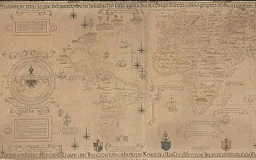 This map by the Portuguese mapmaker Diogo Ribeiro is one of the first examples of political geography manipulating reality. Throughout the early sixteenth century Spain and Portugal were rivals for control of the spice trade, centered on the Moluccas islands in the Indonesian archipelago. In 1494 both powers signed the Treaty of Tordesillas, with a line drawn on a map running through the middle of the Atlantic, with everything to the west belonging to the Spanish, and everything to the east the Portuguese. Following Magellan's first global circumnavigation in 1522, the question was where the line would fall in the eastern hemisphere. The Portuguese Ribeiro switched aides and was paid by the Spanish to make this apparently objective map, full of scientific detail, which shows the Moluccas (in both the far left and right-hand sides of the map) just within the Spanish half of the globe. Modern measurement suggests he was wrong, but it took hundreds of years to disprove his brilliant and extremely effective act of cartographic deception.
See also ref. 015b (Cantino Planisphere map)
©:History of the world in twelve maps
tags: #Tordesillas #Diogo #Ribeiro
ref. # 148a -King Manuel's dream of the river Ganges and Indus
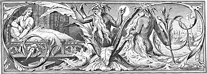 Sonho prof tico de D. Manuel com os rios Ganges e Indo. Numa edi o de Os L, adas.
©: Biblioteca National de Portugal, PD Wikipedia
Sonho prof tico de D. Manuel com os rios Ganges e Indo. Numa edi o de Os L, adas.
©: Biblioteca National de Portugal, PD Wikipediatags: #Os Luciadas #King Manuel #Luiz de Camoes
